Nacimiento-Furgusson Road
This is a gem of a road that I have taken twice. The second time around I purposefully planned my overnight stop to make sure I was able to ride it again before heading North on the PCH. It starts out in the middle of the Fort Hunter Liggett Military Reservation with very smooth roads and some nice twists and turns with a chance at seeing some Army Reservists in action or spotting deer, elk or other California High Desert wildlife. It climbs up through the mountains before dropping off spectacularly to be just a few feet above the crashing surf of the Pacific Ocean. In between you will go through virtual tunnels of tree overhang, hit tight 2nd and 1st gear hairpins and cruise at a relaxing 20 mph on what really amounts to a paved dirt road. Oh and did I mention that it drops to a one lane road to share with oncoming traffic? Don't get caught sightseeing too much or you will end up the hood ornament of a Suburban (Tahoe, Explorer insert big SUV name here). Ask me how I almost know…
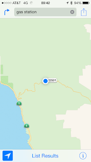
Here is a screen shot from my phone so you can see the map of the road. The super twisty part at the end also drops in elevation a few thousand feet while you negotiate the switchbacks.
Here is what it looks like at the top after about an hour of road from the Base to the coast. It is a good place to stop and rest up before you have to earn your money getting safely down the hill.
Looking back to where I came from. Around the bend to the right is a camp ground area where you will likely run into some of the only traffic you will encounter depending on the day you take the pass.
This is where I'm headed. The dark tunnel of trees will be a constant for another hour or so before you hit the last couple of miles before the coast. Slow and smooth is the name of the ride. This is not a knee dragger.
And this is what you see when you finish. Notice how the weather changed on the way down. The temperature dropped 10 to 15 degrees as I went through the clouds cover. This part of the PCH is popular with campers. Pick a direction, North or South and you can't go wrong. Gas up beforehand as there are not many places to top off. If you can, get up North along the California's Central Coast for some great Motorbike Riding!
Blue


Comments
Post a Comment
Thanks for your comments and for following My Motorbike Obsessions!